Showing posts with label Route Profile. Show all posts

Sunday, June 29, 2014

Deseret Power Railway

Starting in 2005, I spent several years living in Utah while I was in college. One evening, as I was surfing the internet, I came across a reference to a "Deseret Western Railway" being the only electric railroad in the state of Utah. Up to that point, I had always assumed that Utah had no electric railroads. Union Pacific and Utah Railway are the two major railroad presences in that state, and both maintain fleets of diesel locomotives. Since it was located several hours away and I did not own a car at the time, I filed it away in the back of my brain as something I would like to go check out in the future.

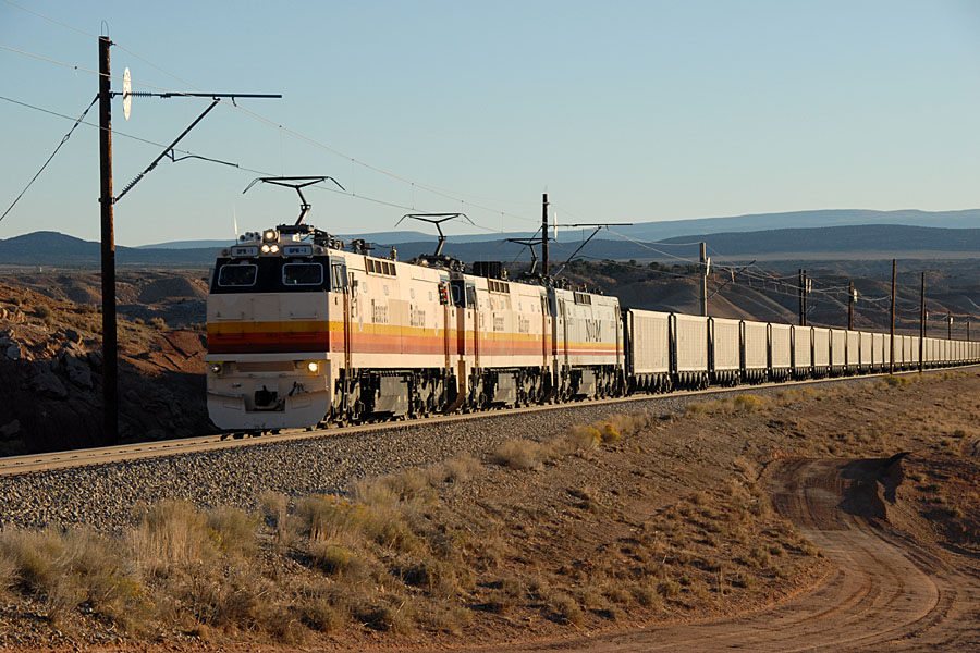
Photo by "Chip" of www.coloradorailfan.com
A couple of years later, I decided to go check out this electric railroad in eastern Utah. A roommate and I were bored one afternoon, and he had just bought a new car a few weeks earlier and wanted to drive. However, he complained to me that he did not know where to go. I suggested we go check out the Deseret Power Railroad and gave him a brief explanation of what exactly it is. He agreed, and off we went.

The Deseret Power Railroad was built in 1984 as the Deseret Western Railway. It is the only electric railroad in the state of Utah, and is not connected to the rest of the North American rail network. The 35-mile railroad is owned by the Deseret Generation and Transmission Co-operative. Coal is moved from the Deserado Mine, near Dinosaur, CO, to the Bonanza Power Unit, a 400-megawatt power plant located near Bonanza, UT. There is a loop on either end of the railroad, and no sidings or stations in between.

All trains operating on the Deseret Power Railroad are electric, using power generated by the coal it hauls. The Bonanza Power Unit generates electricity to operate the railroad and the coal mine, all of which are owned by the same company. The railroad uses seven General Electric E60C locomotives, which draw power from a 50,000 volt overhead catenary.

Our little road trip out to see the Deseret Power Railroad was fun. It was quite something to find this electric railroad line out in the middle of the desert. It does not run directly through any towns, and even the nearby ones are pretty small and isolated. It goes through an area many would call "the middle of nowhere." I took pictures at several locations online. Despite driving to several locations on the railroad, we did not see any trains.

The following photos are some that I took on that trip, the entire bunch of them can be found at the Ogden Brothers Trains Facebook page. You do not need to be a Facebook user to see the photos.

Looking east down the tracks, near the Deserado Mine.
One of the only grade crossings on the railroad, just outside the Deserado Mine.
A rural crossing near the Colorado-Utah border.
There sure is a lot of open land around this railroad!
Catenary support.

Tuesday, October 4, 2011

Route Profile: Southwest Chief

Amtrak's Southwest Chief is a long distance train operating daily between Chicago and Los Angeles. The train covers 2265 miles in about 43 hours. Destinations along the way include Kansas City, Topeka, Albuquerque, the Grand Canyon, and Los Angeles.

The train leaves Chicago on BNSF tracks, which it will follow all the way to Los Angeles. The train follows the same route as the California Zephyr and other short distance trains to Galesburg, where it takes a more southerly route than the Zephyr. The train crosses a small corner of Iowa before making its way across Missouri to Kansas City. The scenery through here is mostly farmland, with the Mississippi River crossing shortly after Galesburg. You will go to sleep in Missouri, probably near Kansas City.

During the night the train crosses Kansas, making a few stops there. You will wake up near the Kansas/Colorado state line. In Colorado you have your first smoking stop of the day, in La Junta, where you can get off the train and stretch your legs for a few minutes. The Colorado scenery on this train is not the same as on the Zephyr, the landscape is mostly plains here. The train does not spend much time in Colorado, because it turns more to the south to get to New Mexico.

Before crossing into New Mexico, the landscape turns more mountainous. The train crosses the Colorado/New Mexico state line and the Continental Divide at the same place, in Raton Pass, at an elevation of over 7000 feet. After crossing the Divide, the train descends the other side of the pass and stops in Raton. The scenery will stay somewhat mountainous across New Mexico. The Southwest Chief does not stop in Santa Fe, but you can get a commuter rail train there from Lamy or Albuquerque. Albuquerque is the train's long stop where it restocks the food and water and everything else on the train, so you are there for almost an hour. There are some vendors on the platform selling New Mexico souvenirs, and they have some pretty cool stuff there.

It will get dark about the time you get to Arizona, and you will sleep across that state. People going to the Grand Canyon get off at Williams Junction, so that is a busy stop. The train makes other stops in Arizona, before you wake up the next morning in southern California. The scenery here is also mountainous, and you will go through the famous Cajon Pass that morning. The pass is very scenic, and if you like trains, there are lots of them. Don't get too comfortable in your lounge seat though, because the train is scheduled to arrive in Los Angeles at 8:15 that morning, and the trip is done.

If you are thinking of visiting Los Angeles or the Grand Canyon, Amtrak's Southwest Chief is the way to go. It's not my favorite Amtrak route, but it is scenic enough to capture your attention. It is one of the faster transcontinental routes, taking less than 48 hours from end to end. This train frequently runs on time, so scheduling issues should not be too much of a concern. This popular train books up quickly though, so grab the tickets while you can!

Tuesday, September 20, 2011

Route Profile: California Zephyr

The California Zephyr is a long distance train run by Amtrak between Chicago and Emeryville, near San Francisco. The entire trip covers 2438 miles and takes about 48 hours to complete. Destinations along the way include Burlington, Omaha, Lincoln, Denver, Winter Park, Grand Junction, Salt Lake City, Reno, Sacramento, and San Francisco. This train operates daily in both directions.


The train leaves Chicago on BNSF tracks and crosses Illinois at a pretty good speed. You stop in a few small towns along the way, but the scenery is mostly cornfields. After Galesburg, the train crosses the Mississippi River on a long bridge. Immediately after the bridge, the train makes a tight turn to the right and enters the station at Burlington. The rest of the day is spent crossing Iowa, which you entered while crossing the Mississippi River. The sun will set before reaching Omaha.


You will wake up the next morning east of Denver. Because of the way Denver Union Station is set up, the train has to enter and leave the station from the same end. The two railroad lines that Amtrak uses to enter and leave Denver both come into the station at the same end. The train will go around a wye and back into Denver station. This is a normal operation, so don't be alarmed. This is where the train takes on water and supplies and a fresh crew, so the train stops in Denver for the better part of an hour. Normally the train uses the original Denver Union Station, but right now Amtrak is using a nearby temporary station because Union Station is undergoing construction for Denver's transit system.


Amtrak leaves Denver on Union Pacific tracks, which it will follow all the way to Emeryville. This is where the ride really becomes cool. Immediately after leaving Denver, the train starts climbing the foothills to the Rocky Mountains. The mountains just rise up out of the plains like a wall standing thousands of feet tall. It's really incredible. The train twists and turns its way up to the mountains, all the while Denver gets smaller and smaller as the train climbs higher and higher above the mile high city. The train disappears into a tunnel, and Denver and the plains disappear out of sight. This area is known as the tunnel district, as there are 28 tunnels in about 50 miles. The longest tunnel is the Moffat Tunnel, which is 6.2 miles long. This is where the train crosses the Continental Divide, and at 9,270 feet above sea level, it is by far the highest of the four transcontinental routes. The Moffat Tunnel was built to reroute trains around Rollins Pass, which was an additional 30 miles and climbed to over 11,000 feet above sea level.


During the summer, a National Park Service representative gets on the train in Denver to narrate the trip in the lounge car. You will spend most of the day crossing Colorado, and the lounge car is the place to be for this. Even with the huge windows going all the way to the ceiling, it is hard to see some of the peaks because they are so high! You will pass through many scenic areas, such as Gore Canyon and Glenwood Canyon. In Glenwood Canyon, if both trains are running on time, you will pass the eastbound California Zephyr. The train parallels I-70 through Glenwood Canyon. Normally an interstate highway might be considered an eyesore, but here it is actually really cool to see how it was built through that canyon.


The National Park Service representative gets off the train at Grand Junction, but that does not mean the scenery is over. After Grand Junction, Colorado gives you one last hurrah as you pass through Ruby Canyon, which is named because of the way the rocks glow red in the sunlight. In Ruby Canyon, you will cross into Utah. The state line is actually painted on the wall of the canyon, so keep your eyes open for that! It is easy to miss, I have only seen it once.


In Utah the scenery gets a little dry, literally. The train turns away from the Colorado River, which it has been following almost since the Continental Divide, and crosses the desert to Salt Lake City. By this time it is evening, and you will sleep across Utah. But it's okay, there's not much to see there except an empty desert. Salt Lake Valley is about the only thing worth mentioning. You go through there in the middle of the night, so you don't really see anything, but it is a cool place to visit.


You'll wake up the next morning in Nevada. The train only makes three stops across the whole state of Nevada, if that gives you an idea of how empty it is. Shortly after waking up, however, the train finds its way into Reno, the biggest little city in the world. A few years ago, Reno dug a big trench and put the railroad tracks in it. This was because the town was built around the railroad tracks, and with today's massive trains, a single train can shut down the town for a while. The trench allowed the railroad to pass through the town without blocking any crossings, because now the roads simply go over the trench. Because of the trench, you can't really see Reno very well.


After Reno the train starts to climb again, this time into Donner Pass. Donner Pass is famous for two separate winter incidents, which I will talk about more in Thursday's post. Donner Pass is in the Sierra Nevada Range, and while in these mountains you will cross into California. After descending the other side of Donner Pass, the train will stop in Sacramento. Sacramento is where the Amtrak California service starts, and the Coast Starlight stops here as well. Only a few shot stops later, you find yourself at Richmond, and then Emeryville. At Richmond, you can detrain and get on BART (Bay Area Rapid Transit) to get into San Francisco, or you can get off at Emeryville and take a bus run by Amtrak into San Francisco. The bus would probably be easier. Once in San Francisco, there is an endless list of things you can do there.


If you are thinking of going on a vacation, I would highly recommend this train. It is by far my favorite of the Amtrak routes, and can be a vacation by itself. But it brings you to San Francisco, which is probably my favorite of the cities I've been to. You could really make an unforgettable vacation by spending, say, a week in San Francisco and getting there and back by rail. Don't forget to check out the California State Railroad Museum in Sacramento as well!

Tuesday, September 6, 2011

Route Profile: Empire Builder

Amtrak's Empire Builder is a transcontinental train, linking Chicago with the Pacific Northwest.  The entire trip, from Chicago, to the end points in Seattle and Portland, takes just about 46 hours, or two nights.  Destinations en route include Milwaukee, the Twin Cities, Fargo, Glacier National Park, Spokane, the Cascade Mountains, and the Columbia River Gorge.

Williston, ND.
All photos by James Ogden.
The Empire Builder travels from Chicago to Seattle and Portland, through the northern United States.  The train serves cities in Illinois, Wisconsin, Minnesota, North Dakota, Montana, Idaho, Washington, and Oregon.  From Chicago to St. Paul, the train travels on the Canadian Pacific Railway and stops in Glenview, a Chicago suburb, and then heads north, parallel to Lake Michigan, to Milwaukee.  Once in Milwaukee, the train turns inland a bit, connecting Wisconsin towns such as Portage and LaCrosse.  The train crosses the Mississippi River three times before finally arriving in St. Paul.  As the train leaves St. Paul, and the Twin Cities, it goes onto BNSF Railway trackage for the remained of the trip.  Heading west, the train travels overnight across Minnesota and part of North Dakota, making night tine stops in places such as St. Cloud, and Detroit Lakes.  The first stop in North Dakota is Fargo, and from there the train heads north to Grand Forks.  In Grand Forks, the train turns west again, and travels across North Dakota.

The Empire Builder in Shelby, MT.
In North Dakota, the train stops in some of the larger areas including Minot and Williston.  Also in North Dakota, the train stops in Rugby, which is the geographic center of North America.  The exact center point is designated by a monument only a short distance from the depot.  Around lunch time, the train crosses into Montana, and into the Mountain Time Zone.  Typically an announcement is made about this, because lunch is served in the Mountain Time Zone, and is therefore postponed one hour.  In Montana, the train continues across the prairie, stopping in small places like Wolf Point and Glasgow.  As it gets closer to dinner time, the train stops in Shelby, and from there heads up into the mountains.  The train crosses the continental divide in Marias Pass.  The train rises to almost a mile high just for a short time as it crosses the pass.  Only 55 miles of this line is above 4,000 feet.  As the train starts over Marias Pass, it also starts into Glacier National Park.  The park is served directly by three stations, including East Glacier Park, Essex, and West Glacier.  Essex is home to the famous Izaak Walton Inn.  Marias Pass is the day's most scenic area, and most people spend the afternoon and evening in the lounge car, watching the views go by.

Cascade Mountains, near Skykomish, WA.
Continuing west, the train descends out of Marias Pass an stops in Whitefish in the evening.  The train then travels overnight across the remainder of Montana, Idaho, and into Washington.  The train arrives in Spokane in the early hours of the morning, and splits into two trains.  Several cars are removed from the rear of the train, and a locomotive off of the front, making two trains.  When they depart from Spokane, one section goes to Seattle and the other goes to Portland.  Passengers do not need to worry about changing trains or cars during this process.  When sleeping car rooms and coach seats are assigned, the destination is taken into consideration, and passengers are on the right section of the train from the start of the trip.

Space Needle, Seattle, WA.
The Seattle section of the train continues west across Washington, crossing over the Cascade mountains.  Wenatchee is another morning stop, and from there the train heads into Stevens Pass.  Stevens Pass was named for John Stevens, who was well known for his work on the Great Northern Railway and the Panama Canal.  At the top of the pass, the train enters the Cascade Tunnel, which, at 7.8 miles long, is the longest railroad tunnel in North America.  The train will be in the complete darkness of the tunnel for about fifteen minutes.  Typically the train passes through the tunnel around breakfast time.  From there, the train descends through the Cascades to Puget Sound.  The entire morning is full of beautiful scenery, and is well worth getting up early to see it all.

Union Station, Portland, OR.
The train typically arrives in Everett towards the end of the morning commute.  From there it heads south, along Puget sound, allowing for some sweeping panoramas of the Olympic mountains across the sound.  The views of Puget Sound also offer a glimpse into the world of commercial shipping, as the Seattle areas have several places where large container and automobile ships arrive from Asia.  After one more stop along the sound, in Edmonds, the train arrives at King Street Station, in in downtown Seattle.  Connections are available to local transit and taxis.

The Portland Section of the train leaves Spokane and heads southwest, towards the Columbia River.  The train then follows the river west, staying on the Washington side of the river.  The best views of the river and the gorge are on the river side of the train.  After several morning hours of traveling along the Columbia River, the train arrives in Vancouver.  After a brief stop there, the train heads south, finally arriving at Union Station, right in downtown Portland.  Connection to the light rail, transit, and taxis is available at Union Station.

Superliner equipment in St. Paul, MN.
Amtrak uses Superliner equipment for the Empire Builder.  Superliners are bilevel rail cars.  Amenities include sleeping cars, a full service dining car, a cafe car, a lounge, with large windows to look at the views through, and roomy coach seats.  Sleeping car passengers have all meals in the dining car included in the price of their ticket.  Dining car meals are available to coach passengers at an additional charge.  The cafe car has a variety of snack and beverage items available from early in the morning to late at night.  This is a non smoking train.  Periodic stops are made to allow people to step off the train to smoke for a few minutes.

Tuesday, May 3, 2011

Railroad Profile: White Pass & Yukon Route

Steven and I have been talking recently, and we had an idea for a model railroad, which I thought I would share.  The White Pass & Yukon Route offers some unique modeling possibilities, but is small enough to fit in a small to medium sized space.  If space allowed, it could also occupy a fairly large space.

The White Pass & Yukon Route is based in Skagway, Alaska, and runs from there, over the White Pass, to Fraser, British Columbia, and Carcross, Yukon Territory.  Eventually, it ends in downtown Whitehorse, YT.  The railroad is approximately 110 miles long, however trains do not regularly operate to Whitehorse.  Most trains do not go any farther than Carcross.

WP&YR Depot and Offices, Skagway, AK.
All photos by James Ogden.
The railroad is headquartered in Skagway, AK.  Skagway is a port town that serves the Yukon, and is a popular cruise ship destination.  Skagway came to be during the Klondike Gold Rush, in the late 1890's, and the railroad itself was founded in Skagway in 1898.  The plan was to build a railroad line all the way to Dawson City, YT, which is about 500 miles from Skagway.  During the Gold Rush, most of the prospectors were headed for Dawson City, to the Klondike River, where the gold was rumored to be.  Before the railroad was built, they would take a ship to either Skagway or Dyea, and then hike over the mountains.  From Skagway, many would go over the White Pass, to the Canadian border, and into the Yukon.  From Dyea, which does not exist today, prospectors would hike up the Chilkoot Trail, where they would cross into Canada and head for the Yukon.  Both passes were dangerous and difficult.  Some enterprising people in Skagway realized that there would be a market for a rail line to Dawson City, and so the White Pass & Yukon Route was founded, and construction began in Skagway.

A train arriving in Skagway.
The White Pass & Yukon Route, as its name implies, took the White Pass over the mountains into the Yukon.  While the White Pass was longer than the Chilkoot Pass, by the distance covered, the grades were less steep and the terrain was less rugged.  Despite the longer distance, that made it more ideal for building a railroad line.  The railroad was never completed to Dawson City, simply because the Gold Rush ended.  Since most of the customer base was to be gold miners, there was no sense in building beyond Whitehorse.  The gold rush was very short lived.  By the time all the prospectors arrived in Skagway or Dyea, got themselves and their gear over the mountains, and then traveled to Dawson City, all the residents of Dawson City had already staked claims where the gold was, and there was very little left.  The gold rush ended with very few of the prospectors ever finding any gold.  However, the railroad was there to stay, and it is because of the railroad that Skagway exists today.  Dyea had no railroad, and when the gold rush was over, the town was abandoned and has disappeared over the last century.

Despite the end of the Klondike Gold Rush, the railroad continued to be an important link from the Yukon to the Pacific Ocean.  For decades, there was no Alaska Highway, connecting Whitehorse to other parts of North America.  The most practical way to ship people and cargo to and from the Yukon was to use Skagway as the port town, and the railroad as the link.  In years since the gold rush, other metal ores have been found in the Yukon.  This lead to the railroad building an ore dock in Skagway, so that the ores, primarily lead ore, could be exported from the Yukon.  At one point the railroad owned ships, barges, tugboats, trucks and a shipping container company to move its cargo.

Car #328, Stewart River, and old wooden car.
As the cruise industry has grown, particularly in Alaska, the business of the railroad has shifted.  Years ago, the ocean going equipment was sold, the container division was absorbed into another company, and the ore cars were set aside.  The old wooden passenger cars were brought back into service, and cruise passengers began booking tours on the White Pass & Yukon Route.  The diesels that once pulled ore through the pass were put to work pulling tourists over the pass.  The tour industry has grown to make the White Pass & Yukon Route the busiest tourist railroad in North America.  It is also the only tourist railroad in the world which crosses an international boundary.  The railroad continues to employ its fleet of antique, wooden passenger cars, with wood stoves for heat.  It has expanded its fleet to include some newer, steel passenger cars, which were designed to be similar in appearance to the older wooden cars.  While tourist operations are currently the primary operations of the railroad, they have recently talked about expanding to haul ore again.

Class 90 diesel locomotive.
The White Pass & Yukon Route is unique for a variety of reasons.  Due to the terrain, it was built at a three foot narrow gauge, rather than the standard, 4' 8.5" gauge of most of North America.  This allowed the railroad to build smaller bridges and tunnels, tighter turns, and lighter equipment.  The railroad still runs two steam locomotives, as well as a rotary snow plow.  The railroad does not run regularly during the winter, but every spring, they do take out the rotary plow for a railfan weekend.  Usually that is in April.  The railroad also has a number of diesel locomotives that they operate, including their famous Class 90 diesels.  Besides the Class 90's, they have several ALCo units, built by Montreal Locomotive Works, and one more modern wide cab locomotive, built by Bombardier.

ALCo diesel locomotive, coupled
between two Class 90's.
Most of the action on the railroad can be found in Skagway, which is convenient for modelling.  Skagway is a small town.  The entire town is four blocks wide by about twenty blocks long.  At one end of town is the waterfront, with the docks. The ore dock still has railroad tracks to it.  The Broadway dock is often used by cruise ships, and there is also a railroad track to that dock.  The railroad dock has tracks out on the dock, and that is also used by cruise ships.  Just north of the docks is the railroad offices, the depot, and the downtown Skagway area.  Skagway, to this day, still has wooden sidewalks and false fronted buildings, just as it did during the gold rush.

The railroad runs up the east side of town, and the railroad shops and yard are at the north end of town, between the mountains and the Skagway River.  Just beyond the shops is the gold rush cemetery, where noteworthy locals, such as Jefferson "Soapy" Smith and Frank Reid.  From there, the railroad continues north into the White Pass.  The Canadian border is at the top of the pass, less than 20 miles from Skagway, but the next town the railroad gets to is Fraser, BC.  From there it continues on to Carcross, and the tracks run all the way to Whitehorse.

Map from www.skagway.com.
A small model railroad could model Just Skagway.  As I mentioned, that is where most of the action is.  Depending on the space available, a model railroad could include just the depot and docks area, with the main line running off to a staging area.  A slightly larger model could also include the yard and shops, again, with the main line running off to a staging area.  In a large space, a portion of the main line could also be built over the White Pass, to Fraser or beyond.  The area the railroad occupies in Skagway actually lends itself to an L or U shaped model railroad quite well.  Such a model could be built and quite accurately represent Skagway.

Bombardier DL-535E(W) diesel locomotive, at the shops.
As far as the railroad goes, the White Pass & Yukon Route is would be a unique and interesting railroad to model.  Because it is not too large, it could be modeled accurately in a fairly small to medium sized space.  The only place where a modeler might run into problems is with the locomotives.  Finding appropriate wooden passenger cars commercially available is fairly easy.  Standard gauge cars could be purchased, and then have new trucks installed.  Even model narrow gauge steam locomotives are common enough.  They can be a little tricker to find, but there have been enough narrow gauge rail lines in the past that steam locomotives are generally pretty easy to find.  The challenge is going to be in finding narrow gauge diesel locomotives.  I know that the Class 90's have been commercially manufactures, in brass, but they are quite rare, and being brass models, they can be quite expensive.  Kits have been offered off and on for the ALCo locomotives, and those are usually affordable.  Finding a narrow gauge ALCo fully assembled is also tricky.  As far as the Bombardier locomotive goes, that would almost certainly need to be scratchbuilt.  The railroad only owns one though, so a modeler could even leave it out of their fleet.  Of course, choosing to model the railroad when they only operated steam locomotives would eliminate the need for any of the rare and unique diesel locomotives.  Overall, I think the White Pass & Yukon Route lends itself quite well to model railroading, and with its history, there are a lot of modeling possibilities.